Weekend at Three Rivers

January 25 -27, 2013

Three Rivers, New Mexico

It was exactly one month ago that we passed this way, camping overnight at the Three Rivers National Petroglyph Site, on our way to Carlsbad Caverns.

At the Petroglyph Site

It was my intention to do an inventory of the greeting cards that I sell at the Three Rivers Trading Post and Gallery, but the gift shop was closed both coming and going from the campsite.  Cold wind followed us all the way south.

So, now a month later, with the temperatures moderating from what they were, we make another trip to Three Rivers, only this time we decided to go all the way into the Three Rivers Campground which is located at the foot of the Sacramento Mountains on the border of the White Mountain Wilderness.  This is one of most favorite places to camp, and this time of the year, there is almost no one else here.

We arrive late afternoon on Friday and are greeted at the sign-in kiosk by John, the camp host, who has been here for 20 years.  We met him on our first trip to this campground at least 12 years ago and as always, find him to be friendly and welcoming.  We are sad to hear that he will be leaving Three Rivers in May.  Very unfriendly federal regulations are changing the way things have been done, so John and his family will be moving on after all these years of service.

We get the Pony (our small pop-up made by the Palomino Company) set up before dark

Pony is Set Up
Pony is Set Up

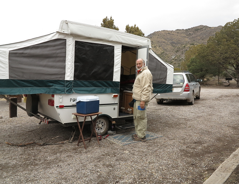
and soon the interior is arranged with sleeping quarters at one end, food, dishes, clothing, books, and laptops on the other end.  In the middle are our table and benches, stove, and sink.  We are set for a comfortable weekend.

The evening passes quickly with journal writing (me), studying (Clifford), and dinner.  Before we head to bed, we spend a little time poring over the Adventure Atlas, seeing the many tiny green tents that indicate places we might want to visit someday.

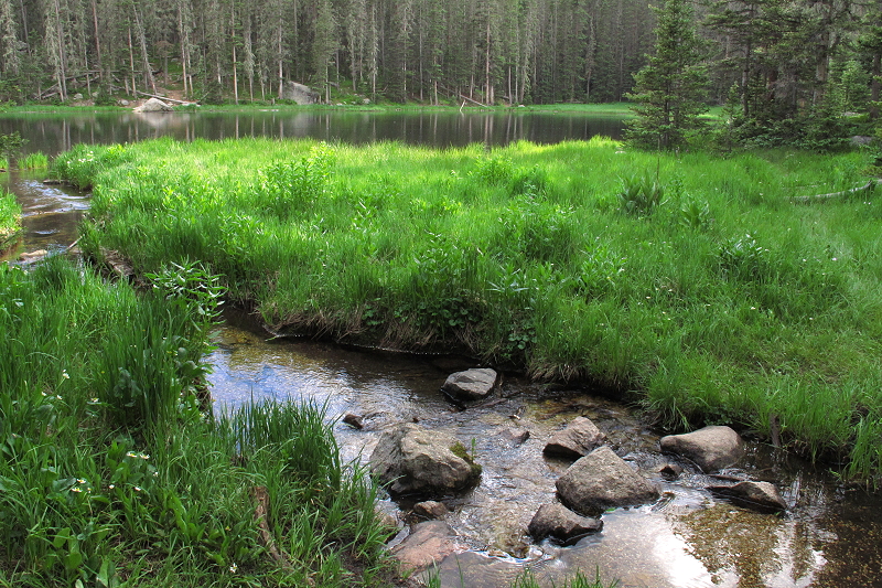
Saturday morning, as the first light of the day wakens me, I get up, pull sweats on and a long coat, grab my camera, and head out the door.  I first go down to the creek and am delighted to find water flowing.

The Creek Still Flows

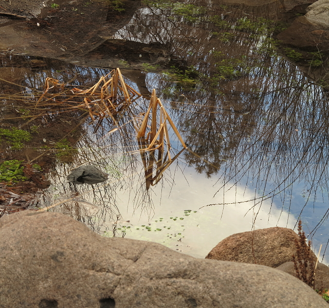
A year ago Thanksgiving when we were here, the creek had all but dried up, thanks (but no thanks) to the drought in New Mexico.  I tromp along the rock-strewn creek, crisscrossing by stepping from boulder to boulder, taking photos of reflections on the pools.

Reflections on the Creek

During spring run-off, the creek has more water and is actively tumbling over its rock bed, but now, it is a series of little pools connected by a gently meandering stream of water.

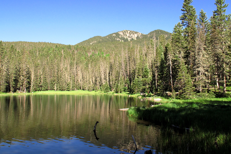
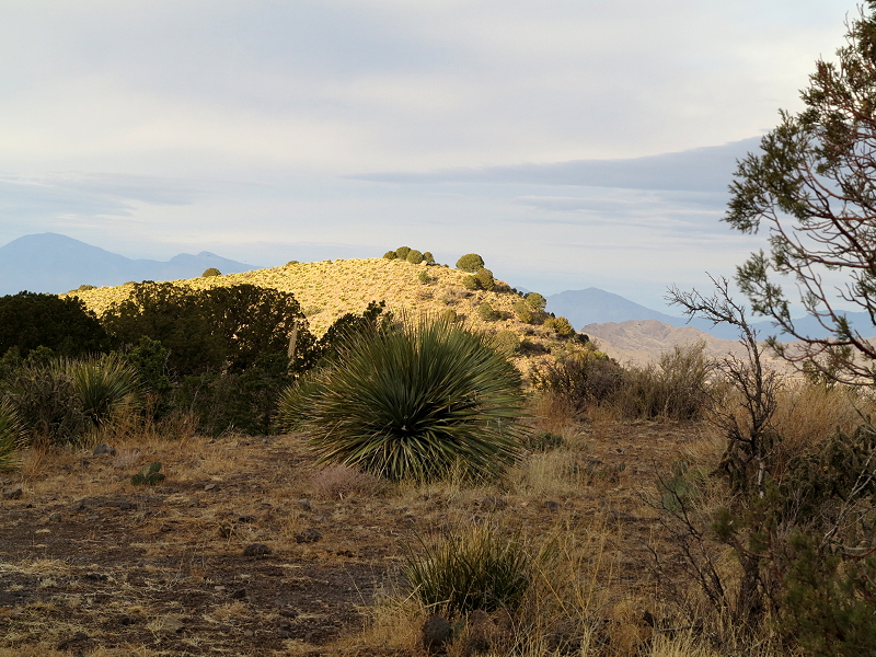
Then I follow a little-used gated road up to the top of a nearby hill.  From here I have a great view all around:  the White Mountain Wilderness to the east immediately behind the campground,

White Mountain Wilderness

the yucca-covered hill to the north; across the Tularosa Basin to the west are the San Andres Mountains –  the barely-discernible pale strip at their base is White Sands Monument and Missile Range, while south looks at the foothills of the Sacramento Mountains across the plains toward Tularosa and Alamogordo.  I am hoping to get some light on the mountains as the sun clears the ridge, but the sun is hidden behind a dense overcast when it rises from behind the mountain top.  After a while I head back down, picking up a few dry twigs in case I decide to have a campfire later in the day.

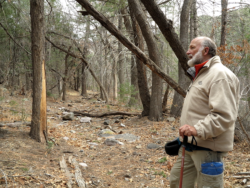
Back at camp, Clifford is up and we chat with John about things we see going on in this country that could cause civil unrest, unless complacency wins out.  After breakfast, we work on our projects before heading out for a hike.  We hike into the wilderness, going in maybe a mile or so, enjoying the mild temperatures, the sprinkle of rain, the wildness of the landscape.

Hiking in the Wilderness

Sometime in past years, the gentle little creek has been a raging river tearing down the mountainside, displacing rocks and boulders and reshaping the land.  At some point in time, a horrific wind has ripped through here snapping off dozens or huge pine trees.  Today, there is only a gentle breeze and the creek is charming flow of water.

Gently Flowing Creek

We see lots of fresh elk tracks and come upon a recently dead elk, antlers still intact, though his flesh has been the meal for many a creature of the forest.  Rather than being offended by the remaining smell, I try to see the cycles of nature in the remains.  Other odd smells make us wonder if sasquatch live here.  Hmmmmm…………….

We finish out the day with tending to meals and our projects, the evening project for Clifford being drawing and for me, writing and editing.  Sprinkles of rain and the wind picking up make us very glad for the comfort of the Pony.

Sunday morning light draws me outside and again I hike up the gated road for the views and some photos of the morning light hitting a nearby hill and the San Andres Mountains to the west.

Sunlight on the Hill

Back at camp, I am reluctant to confine myself to the Pony, so I decide to make a campfire in the fire ring.  A cheery campfire provides a warm spot to write in my journals while I wait the coming of warmth of sunshine.  Beautiful cumulus clouds float against a blue sky, sunshine coming and going.  After Clifford makes breakfast, it is all-too-soon time to begin packing up.

On our way back out to the highway, we stop at the Santo Nino Atocha Chapel, a remote Catholic chapel nestled in at the base of the Godfrey Hills, dedicated to the Holy Child of Antioch.

Santo Nino Atocha Chapel

I take photos of the chapel before heading on to the Three Rivers Trading Post, where I do the greeting card  inventory.  Then we head on down the road, arriving home after dark, already looking forward to our next road trip in the Pony.

Backpacking to Stewart Lake

Our backpacking trip to Stewart Lake in the Pecos Wilderness in the Sangre de Cristo Mountains of New Mexico begins with carefully packing our backpacks, doing what we can to keep the weight down.   We have been to Stewart Lake before and I remember it being a strenuous hike.  We are older now, but hopefully wiser, with better gear and more experience under our belts.

Image
Creek Crossing

There are at least three ways to get to Stewart Lake.  On this trip we start at the trailhead at Holy Ghost Campground and hike the Holy Ghost Trail which will eventually leave the Holy Ghost drainage as it winds upward to the ridge-top where it meets the Winsor Trail before going on to the lake.   The first part of the trail is fairly level with a variety of vegetation:  aspen, pine, spruce, a variety of shrubs and grasses,

2012-06_Stewart_G 028
Gradually Ascending

and an assortment of wild flowers provide much for the eye to behold as the trail follows the meandering creek.

Image
Wild Rose
Home for the Night
Home for the Night

About a mile in, after crossing Holy Ghost Creek, we find a level spot a little ways off the trail and here we spend the night.   We sleep in, as steep mountain slopes on both sides of the Holy Ghost drainage block the sun; there is no direct sunlight to get us up and going.   We have our breakfast, pack up, and then head out on the more challenging leg of our journey.

Aspen and Ferns
Aspen and Ferns

It is a beautiful hike, sometimes through aspen forests with fern undergrowth, ponderosa pine old spruce forests with little undergrowth, but with a wonderful spruce-forest smell.  Generally, north slopes have a thick carpet-like undergrowth of small shrubs, grasses, and flowers, while south slopes are more barren except for the tall mature trees that grow there.   We trek uphill a ways and then back down to cross the creek; then uphill and down with another creek crossing –  several times, each time with some elevation gain.   Then we leave the drainage and it is up and up and up.

Ferns and Flowers
Ferns and Flowers
Image
Lady Slipper Orchid
Image
Clifford Delighted to Reach the Ridge

It is with much relief that we reach the top of the ridge where we take off our packs to rest while we enjoy a lunch of sardines, hard-boiled eggs, nuts, and dried fruit.   Although the hardest section is now behind us, we still have a couple more miles to go.

Image
Wild Flower at the Ridge

About another mile in, we are pleased to see Winsor Creek.  There is a trail that forks off to the west to even higher elevations where the real troopers hike or backpack up to Spirit Lake or Lake Katherine.   We are quite happy to reach Stewart Lake and after hiking part way around the lake, we find a camping spot that is not in the lake basin, but is near an absolutely delightful little creek that tumbles over rocks, creating miniature waterfalls, until in runs into Stewart Lake.

Stewart Lake - Pecos Wilderness
Stewart Lake – Pecos Wilderness
Image
Miniature Waterfall
Flowing into Stewart Lake
Good-bye to Stewart Lake

Soon the sun will set, so we make our dinner, enjoy a cup of tea, delight in the cool mountain air, and soon head to bed for a good night’s sleep.  Although we’d love to have a couple more days to hang out here in this wonderful wilderness, we have obligations that will take us back down the mountain tomorrow.  Different muscles will be taxed and we will be sore for a few days, but we have the satisfaction of having accomplished what we set out to do – a back-packing journey to Stewart Lake.

Nambe Lake

Nambe Lake Backpacking Trip –  1,800 foot elevation gain, about 3 ½ miles each way.

Friday, September 21, 2012 – We arrive at the Santa Fe ski basin and are on the trail to Nambe Lake a little after 3:00.  Uphill to the wilderness boundary – about 800 foot gain – then slightly downhill, descending 400 feet, to the Nambe Lake trail junction.  At the junction, the trail climbs steeply upward over rocks and exposed tree roots, hardly a trail in many spots, steep and challenging.

The Rocky Trail to Nambe Lake

Alongside the trail, a wonderful little creek tumbles downhill over boulders, making little waterfalls here and there, quite magical in its descent.

Delightful Little Creek

Being as late as it is, we don’t have time to stop for photos or even for the break that I am needing.  This steep uphill is challenging for me, especially with the pack being heavier – warmer clothes for the cooler temps.  We finally, gratefully, reach Nambe Lake about 6:00 after 1,000 foot elevation gain.  Nambe Lake sits in a mountain bowl with rock-faced cliffs on the east and south and with steep treed slopes on the north and west.

Nambe Lake – View to the South

Then we look for a campsite.  We find one on a bench on the west side of the lake.   The fire-ring is surrounded by fallen longs and we find a spot just barely big enough to set up the tent just outside the ring of logs.  Clifford gets a little cook-fire going right away so we can heat water for tea.  He is feeling a little dizzy and we figure having hot tea will be relaxing and refreshing.

Our Camp at Nambe Lake

Just before the sun goes down, there is a wonderful golden color on the cliff-face to the east.  I get a few photos before the color fades.

Golden Cliff
Golden Reflections on Still Waters

We make raman for dinner with dried spinach, peas, and salmon added – much tastier and more nutritious than plain raman.  After dinner and clean-up by lantern-light, we hang the food bag and then head to bed.  I am sleeping in my bathrobe, warmer, but heavy to pack in.

Woke up in the night with painful cramps in my thigh.  Happened several times.

Saturday, September 22, 2012 – Daylight and I wake up having no idea what time it is, so doze off and on several times before finally getting up.  Gather some small twigs to start the cook fire. Clifford is soon up, so he takes the twigs and gets the little fire started.  We heat water for hot drinks and have enough hot water left for our oatmeal for breakfast.

Heating Water for Hot Chocolate on the Cook-Fire

After breakfast, we hike around the lake.  There is a really pretty campsite at the end of the lake, but someone was there when we arrived yesterday.  They are gone now and we didn’t even hear them leave.  This is where I’d like to camp if we make another trip up here.  As we hike around this small lake, I take photos here and there of the reflections on the calm water and of the autumn colors.

Nambe Lake – View Southwest
Across the Lake

When we get back to camp we have hot tea, do crosswords puzzles, Clifford reads and I write in my small backpacking journal.   While Clifford naps after lunch, I do some editing – about 50 small-print pages of the novel “Emperors and Exiles.”  Along with taking photos of the lake, the editing keeps me busy until dinner.

We go down to the lake outlet for more water as the sun is setting.

End of Daylight

The wind comes up, but we have a cheery campfire and a hot dinner.

Cheery Campfire

After dinner and cleanup, as soon as the fire burns down, we head to bed.

A wonderful Autumn Equinox day.

Slept better – warm in tent even though it is windy all night.

Sunday September 23, 2012 – I am up before Clifford and start collecting twigs to start a fire.  He is up by time I get back from my wanderings.  We get a fire started and heat water for hot chocolate.  Blue sky is becoming obscured by hazy clouds.  Still windy off and on.  Oatmeal for breakfast and then wash up – head to toe for me after dishes are done.  Start packing.   Do another crossword puzzle and thought I would start reading the new Backpacker, but it is later than we thought, so we finish packing and head on down the trail.

Steep going down, but a lot easier than the going up.   Part way down, the women ahead of us have taken a wrong trail.  We continue on a ways, but Clifford is concerned, so we take off our packs and he goes back to see if he can find out if they are okay.  He isn’t gone very long, as he as figured what they had to do to get back onto the main path along the creek.  It is no wonder hikers get lost up here every year; the trail just isn’t obvious much of the time.  On down we go.

Once we reach the junction, it is uphill to the boundary and then the last steep downhill to the ski basin, taking photos along the way.   It is so pretty  – I love the rocks and the golden-leaved aspen.

Trail of Gold
Colors of Autumn

Back in Santa Fe, we run a couple of errands and then Harry’s for dinner, sitting in the garden with all the strings of lights on.  Very charming.    So ends the successful outing to Nambe Lake.

Bosque del Apache at Dawn

Gentle Beginnings

A black pickup passes me on the dark stretch of highway between Sand Antonio and the Bosque del Apache National Wildlife Refuge. It is not quite 6:00 AM and only the faintest light on the eastern horizon distinguishes the still black mesa from the almost black sky. I don’t drive too fast here as the road is narrow with no indication of a shoulder.

When I reach the Bosque del Apache Tour Loop, I drive out to the flight deck, which is my favorite place to set up camera and tripod for shots of the snow geese and Sandhill Cranes as they do their morning fly-out. I pull into the parking lot next to the black pickup that passed me only moments ago. There are only a couple other vehicles here at this time of the morning. The flight deck is reached by a little walking bridge that takes me to a platform over the water. I set up my tripod and camera in the dark, check the settings, decide on a high ISO setting, wide-open aperture, and no polarizer to get shots at first light. Then I wait patiently, sipping hot tea from my thermos, listening for the birds to stir and watching the slowing increasing glow on the horizon in front of me.

I am warmly dressed, as it is cold out here at this time of day -the water near the edge of the pond is frozen – but even so, my hands get cold as I take gloves off to handle camera dials. Soon more and more people arrive. Some, like me, come with cameras and tripods, others have point and shoot cameras, some just hold up cell phone to take photos, quite a few come with binoculars, others with dogs or small children. Old and young come here every morning to watch the natural spectacle of thousands of birds flying up from the yet dark and silent pond.

On A Golden Pond

Now I can hear the snow geese stirring. They sound like a bunch of yappy little dogs. Usually none of the snow geese flocks are close to the flight deck, but this morning there is a small flock not far out. The Sandhill cranes are way over on the other side of the pond, looking like black lumps as they stand sleeping with their heads tucked under their wings. The light from the still hidden sun brings a glow to the horizon, slightly illuminating the pond.

Snow Geese Fly-out

Then the yapping becomes strident and with a roaring whirr, thousands of snow geese rise up out of the water on the far side of the pond. The density of their wings and bodies darkens the horizon. There is not enough light to get good clear photos, but I shoot like crazy anyway, filled with unexplainable joy at the sound of this mass exodus from the pond. This happens several times as flocks of thousands rise up one after another.

Glorious Sunrise

The sky becomes a more intense golden color on the eastern horizon and the water on the far side of the pond takes on a deep orange hue. I can see the cranes still looking like so many black lumps out there in their orange pool. All over the pond, ducks are busily feeding, spending most of their time with heads under water and tails tipped skyward. By now I have changed my ISO and aperture several times in relationship to the available light. The sky pales and then right at the horizon an intense white glow signals the rising of the sun. A lingering flock of snow geese to the south of the flight deck rises with a whirr and crosses over us on its way to the feeding grounds to the north. They fly so close and fast, I am unable to photograph them, but I am thrilled to see their bodies glowing golden as the light of the just-risen sun catches them in flight.

Into the Light

Now I turn my attention back to the cranes, who, as they awaken, make a gurgling cooing sort of sound. The cranes begin walking slowly northward and as they cross the beam of sunlight reflected on the pond, I take photos of them. Now and then some of them take flight, but most are still pond-walking until they are out of my line of sight.

Two bald eagles are spotted in the dead tree across the pond from the flight deck. I change lenses to get a closer shot of them. I have seen them in that tree on previous trips to Bosque del Apache, but it is exciting to see them again. I know this is not the best angle to get a good photo of them, but it will have to do for this morning.

I take a few more shots of ducks bobbing about near the flight deck before reluctantly packing up my camera and tripod. Daylight is here, the geese and cranes are gone for the day, and it is time for me to head back to Socorro where Clifford is waiting. I am sorry he has missed this morning’s outing, but we will be back this afternoon to witness the fly-in as 24 thousand snow geese and over 11 thousand Sandhill cranes return to the safety of the pond for the night.

Backpacking on the Borrego Trail

Image

Tesuque Creek Crossing

May 5, 2012 –I crawl out of bed as the sunlight reaches the top of the far ridge.  It is quite chilly, but we decide to forego a morning campfire, since we will be hiking after breakfast.   We eat our breakfast – granola, a smoothie, and hot tea- as we sit on boulders in the sunshine.

Yesterday afternoon Clifford and I backpacked in on the Borrego Trail to camp at the same spot we camped when we came up here in September.  We had intended to backpack to Stewart Lake in the Pecos Wilderness, but found out just before we left that that there was most likely snow on the trail – over 3 feet just a couple of weeks ago and it has not yet melted off.  So, we changed our directions and drove up Hyde Park Road behind Santa Fe to the Borrego Trailhead and hiked up the Borrego Trail instead.   Uphill and down, I can tell that I’m not in as good condition as I’d like to be.  At the Tesuque Creek crossing, the water coming down the creek was higher than I’ve seen before, so Clifford carried my pack over for me.  Then we made our way off the trail and upstream to our campsite.   We set up camp and soon had a cheery campfire going.   Dinner was refried beans and raman noodles – easy stuff to fix and eat.  After cleaning up, we enjoyed a cup of tea at our campfire.  The moon rose full in the east and Venus to the west was hugely bright.  Soon to bed in our new little backpacking tent – light enough to carry and roomy enough to get in and out of bed with ease.

Image

Our Cheery Campfire

Now, with the morning sunshine warming the crisp mountain air, we prepare for the hike which will be cross-country using GPS and compass, with our destination being a small mountain meadow.   Clifford has plotted a journey for us, but many deep ravines and steep side hills force us to change our directions.  We see lots of deer sign as we make our way amongst tall ponderosas, dense scrub oak, and scruffy fir trees.  Deadfall and good size rocks abound, making hiking challenging.  Eventually we reach a ridge-top knoll where we rest on a big fallen log and enjoy our lunch of hard-boiled eggs, cheese, and an avocado.

Image

Cross-country Hiking

Thanks to Clifford’s skills, we are not lost, even though we are a bit off our route.  We soon drop down to the Winsor Trail for an easier route back to camp.  The Winsor Trail traverses the mountain behind Santa Fe from Tesuque to the ski basin and beyond.    As we hike along in the direction of our campsite, the trail crosses the meadow that was our destination.  It is a lovely spot, more open than most of the terrain here, but no water for camping.  Further on is the junction to the Borrego Trail which takes us back toward Tesuque Creek and our campsite.

Image

Mountain Meadow

On the map, one can see a triangle created by the Borrego Trail, the Bear Wallow Trail and the Winsor Trail.  Each leg of this triangle is about a mile, although the Winsor Trail goes on for many miles either direction of the junctions with the two shorter trails.  The Winsor Trail is a favorite of serious bicyclists and hikers, while the Borrego/Bear Wallow/Winsor triangle is great fun for casual hikers and folks taking their dogs out for a good walk.

Back at camp, we lounge around for the rest of the afternoon, reading and writing a bit.  I love the article in my Outdoor Photographer magazine, ”Realizations”, by Dewitt Jones, photography being a spiritual practice for him, which I totally relate to.  I walk around taking photos of the creek, sunlight in the aspens, little red shooting-stars, and anything else that catches my attention.  Clifford studies his new GPS unit, learning more about its capabilities.   We are surrounded by tall ponderosa and aspens, and I marvel at their beauty.   When the breeze picks up, these 80-100+ foot trees sway in the wind, and I hear one behind our camp making creaking sounds.   Hmmmm….   Hope its roots are well anchored.  As the sun approaches the western horizon, the temperature drops and once again we enjoy a lively campfire, a tasty dinner, and another night of sleeping where the sound that prevails is that of a rough and tumble mountain creek.

Image

The Trees Are Tall

For anyone wishing to go backpacking or just a good hike, this is a great place. But please please please take all of your trash out with you.  Keep this pristine area clean for the person coming behind you and for your next visit here in the Sangre de Cristo Mountains of northern New Mexico.

Image

Intrepid Duo