Backpacking to Stewart Lake

Our backpacking trip to Stewart Lake in the Pecos Wilderness in the Sangre de Cristo Mountains of New Mexico begins with carefully packing our backpacks, doing what we can to keep the weight down.   We have been to Stewart Lake before and I remember it being a strenuous hike.  We are older now, but hopefully wiser, with better gear and more experience under our belts.

Image
Creek Crossing

There are at least three ways to get to Stewart Lake.  On this trip we start at the trailhead at Holy Ghost Campground and hike the Holy Ghost Trail which will eventually leave the Holy Ghost drainage as it winds upward to the ridge-top where it meets the Winsor Trail before going on to the lake.   The first part of the trail is fairly level with a variety of vegetation:  aspen, pine, spruce, a variety of shrubs and grasses,

2012-06_Stewart_G 028
Gradually Ascending

and an assortment of wild flowers provide much for the eye to behold as the trail follows the meandering creek.

Image
Wild Rose
Home for the Night
Home for the Night

About a mile in, after crossing Holy Ghost Creek, we find a level spot a little ways off the trail and here we spend the night.   We sleep in, as steep mountain slopes on both sides of the Holy Ghost drainage block the sun; there is no direct sunlight to get us up and going.   We have our breakfast, pack up, and then head out on the more challenging leg of our journey.

Aspen and Ferns
Aspen and Ferns

It is a beautiful hike, sometimes through aspen forests with fern undergrowth, ponderosa pine old spruce forests with little undergrowth, but with a wonderful spruce-forest smell.  Generally, north slopes have a thick carpet-like undergrowth of small shrubs, grasses, and flowers, while south slopes are more barren except for the tall mature trees that grow there.   We trek uphill a ways and then back down to cross the creek; then uphill and down with another creek crossing –  several times, each time with some elevation gain.   Then we leave the drainage and it is up and up and up.

Ferns and Flowers
Ferns and Flowers
Image
Lady Slipper Orchid
Image
Clifford Delighted to Reach the Ridge

It is with much relief that we reach the top of the ridge where we take off our packs to rest while we enjoy a lunch of sardines, hard-boiled eggs, nuts, and dried fruit.   Although the hardest section is now behind us, we still have a couple more miles to go.

Image
Wild Flower at the Ridge

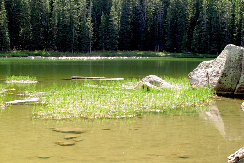
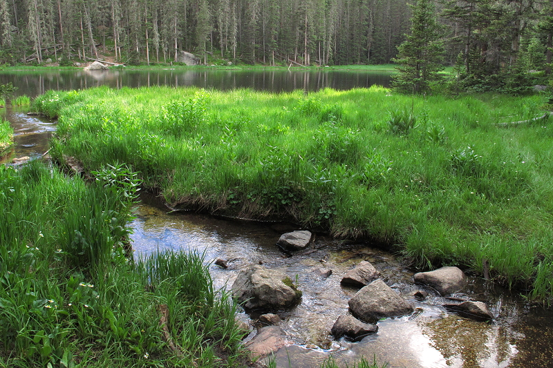
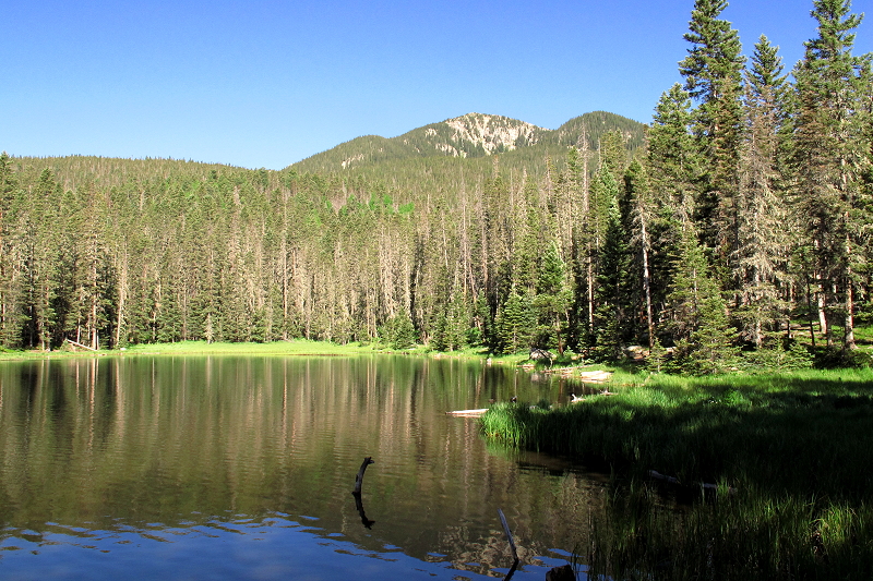
About another mile in, we are pleased to see Winsor Creek.  There is a trail that forks off to the west to even higher elevations where the real troopers hike or backpack up to Spirit Lake or Lake Katherine.   We are quite happy to reach Stewart Lake and after hiking part way around the lake, we find a camping spot that is not in the lake basin, but is near an absolutely delightful little creek that tumbles over rocks, creating miniature waterfalls, until in runs into Stewart Lake.

Stewart Lake - Pecos Wilderness
Stewart Lake – Pecos Wilderness
Image
Miniature Waterfall
Flowing into Stewart Lake
Good-bye to Stewart Lake

Soon the sun will set, so we make our dinner, enjoy a cup of tea, delight in the cool mountain air, and soon head to bed for a good night’s sleep.  Although we’d love to have a couple more days to hang out here in this wonderful wilderness, we have obligations that will take us back down the mountain tomorrow.  Different muscles will be taxed and we will be sore for a few days, but we have the satisfaction of having accomplished what we set out to do – a back-packing journey to Stewart Lake.

Nambe Lake

Nambe Lake Backpacking Trip –  1,800 foot elevation gain, about 3 ½ miles each way.

Friday, September 21, 2012 – We arrive at the Santa Fe ski basin and are on the trail to Nambe Lake a little after 3:00.  Uphill to the wilderness boundary – about 800 foot gain – then slightly downhill, descending 400 feet, to the Nambe Lake trail junction.  At the junction, the trail climbs steeply upward over rocks and exposed tree roots, hardly a trail in many spots, steep and challenging.

The Rocky Trail to Nambe Lake

Alongside the trail, a wonderful little creek tumbles downhill over boulders, making little waterfalls here and there, quite magical in its descent.

Delightful Little Creek

Being as late as it is, we don’t have time to stop for photos or even for the break that I am needing.  This steep uphill is challenging for me, especially with the pack being heavier – warmer clothes for the cooler temps.  We finally, gratefully, reach Nambe Lake about 6:00 after 1,000 foot elevation gain.  Nambe Lake sits in a mountain bowl with rock-faced cliffs on the east and south and with steep treed slopes on the north and west.

Nambe Lake – View to the South

Then we look for a campsite.  We find one on a bench on the west side of the lake.   The fire-ring is surrounded by fallen longs and we find a spot just barely big enough to set up the tent just outside the ring of logs.  Clifford gets a little cook-fire going right away so we can heat water for tea.  He is feeling a little dizzy and we figure having hot tea will be relaxing and refreshing.

Our Camp at Nambe Lake

Just before the sun goes down, there is a wonderful golden color on the cliff-face to the east.  I get a few photos before the color fades.

Golden Cliff
Golden Reflections on Still Waters

We make raman for dinner with dried spinach, peas, and salmon added – much tastier and more nutritious than plain raman.  After dinner and clean-up by lantern-light, we hang the food bag and then head to bed.  I am sleeping in my bathrobe, warmer, but heavy to pack in.

Woke up in the night with painful cramps in my thigh.  Happened several times.

Saturday, September 22, 2012 – Daylight and I wake up having no idea what time it is, so doze off and on several times before finally getting up.  Gather some small twigs to start the cook fire. Clifford is soon up, so he takes the twigs and gets the little fire started.  We heat water for hot drinks and have enough hot water left for our oatmeal for breakfast.

Heating Water for Hot Chocolate on the Cook-Fire

After breakfast, we hike around the lake.  There is a really pretty campsite at the end of the lake, but someone was there when we arrived yesterday.  They are gone now and we didn’t even hear them leave.  This is where I’d like to camp if we make another trip up here.  As we hike around this small lake, I take photos here and there of the reflections on the calm water and of the autumn colors.

Nambe Lake – View Southwest
Across the Lake

When we get back to camp we have hot tea, do crosswords puzzles, Clifford reads and I write in my small backpacking journal.   While Clifford naps after lunch, I do some editing – about 50 small-print pages of the novel “Emperors and Exiles.”  Along with taking photos of the lake, the editing keeps me busy until dinner.

We go down to the lake outlet for more water as the sun is setting.

End of Daylight

The wind comes up, but we have a cheery campfire and a hot dinner.

Cheery Campfire

After dinner and cleanup, as soon as the fire burns down, we head to bed.

A wonderful Autumn Equinox day.

Slept better – warm in tent even though it is windy all night.

Sunday September 23, 2012 – I am up before Clifford and start collecting twigs to start a fire.  He is up by time I get back from my wanderings.  We get a fire started and heat water for hot chocolate.  Blue sky is becoming obscured by hazy clouds.  Still windy off and on.  Oatmeal for breakfast and then wash up – head to toe for me after dishes are done.  Start packing.   Do another crossword puzzle and thought I would start reading the new Backpacker, but it is later than we thought, so we finish packing and head on down the trail.

Steep going down, but a lot easier than the going up.   Part way down, the women ahead of us have taken a wrong trail.  We continue on a ways, but Clifford is concerned, so we take off our packs and he goes back to see if he can find out if they are okay.  He isn’t gone very long, as he as figured what they had to do to get back onto the main path along the creek.  It is no wonder hikers get lost up here every year; the trail just isn’t obvious much of the time.  On down we go.

Once we reach the junction, it is uphill to the boundary and then the last steep downhill to the ski basin, taking photos along the way.   It is so pretty  – I love the rocks and the golden-leaved aspen.

Trail of Gold
Colors of Autumn

Back in Santa Fe, we run a couple of errands and then Harry’s for dinner, sitting in the garden with all the strings of lights on.  Very charming.    So ends the successful outing to Nambe Lake.

Spirit Lake Backpacking Journey

Journey to Spirit Lake

Friday, July 20, 2012: We leave from the Santa Fe Ski Basin at noon and begin the 6 ½ mile hike with 1400 elevation gain, arriving at Spirit Lake a little after 5:00pm. It is uphill from the get-go all the way to the Wilderness boundary and the trail to Raven’s Ridge.

Uphill from the Get-G02
Uphill from the Get-Go

Then a little reprieve from the uphill, but not for long. We hike through aspen forests,

Aspen Forests

spruce forests, little meadows,

Mountain Meadows

down to creek drainages

Tumbling Along

and up again several times.  At the 2nd drainage, we stop for lunch in a spruce forest with huge boulders all around.  We eat our snack of hard-boiled eggs, cheese, granola bars, and trail mix. Clifford takes a 10 minute nap covered with his jacket to keep the mosquitoes off. My left foot had started hurting early in the hike, so I massage it as he naps. The pain in the foot eases up as we continued on, but pain in the hip joints and inner thighs increases as we ascend. Stepping over and around rocks and exposed roots is part of the trail plan here; thank goodness for hiking sticks.

Rocky Road

Eventually we arrive at a very large beautiful meadow sprinkled and bordered with healthy blue spruce.

Blue Spruce Meadow

Most of the spruce on this hike are Englemann spruce, very scraggly looking for the most part, but here the spruce look like perfect Christmas trees – full branches all the way to the ground and every branch tipped with the bluish color of new growth. The vegetation underneath is short and even like a vast lawn. This would be a lovely place to stay, but no water here, we are not prepared for a dry camp, and besides, our destination is Spirit Lake, at least a couple of miles further on. We enjoy this especially beautiful and level section of the trail. The blue spruce give way to the Englemann spruce and the trail begins to hug the mountainside – very steep slopes both above and below us. Fortunately, there is not a lot of elevation gain or loss, as we are feeling the effects of the journey. We are delighted to catch our first glimpse of Spirit Lake, a very green mountain lake backed by a very steep mountain slope.

Spirit Lake

We are beat (but not exhausted), our feet are hurting and we are ever so happy to put our packs down where there is some level ground. We scout around for a spot to set up camp. The spot where we set up our packs is where Clifford camped when he came up here years ago by himself while I was in Montana. It would be an okay spot, but there is a large group of backpackers nearby. We would prefer to give them and ourselves a bit more privacy. Another spot is quite nice, but we can’t see the lake. I decide to explore the slope to the west of the trail. It looks like it is too steep to offer a camping spot, but I feel drawn to check it out, anyway. I am quite happy to discover a bench not discernable from the trail or from the lake below. There is a stout fire ring, a couple of spots level enough for the tent, and a great view of the lake.

View from the Camp

This is where we decide to set up camp. I take a couple shots of the lake, but am too tired to do a walk-about. We get the tent set up, build a cheery campfire (the fire ban has been lifted), and get dinner started.

Rocky Road

After burritos, mac/cheese for Clifford, and hot tea we are feeling our strength returning somewhat, but we go to bed soon after cleaning up after dinner. Even though I’m tired, I don’t fall asleep right away – maybe too tired, legs and feet still hurting, and little noises. I crawl out of the tent to look around – pitch black out here, not even any starlight or moonlight. Once I have reassured myself that everything is okay, I get back into the sleeping bag and sleep a restless sleep, thinking about needing better nutrition to support the body doing this backpacking.

Saturday morning I wake up after the sunlight is on the slope; due to the denseness and height of the trees, it is only little slivers of light coming through which move with the rising of the sun. I get up and with camera in hand I go exploring, first down to the lake with the lovely reflections of the early morning on the water.

Reflections on the Lake
Morning Reflections

and then up the boulder and spruce covered slope behind the camp. The trees here are tall, but the downfall rate is significant, I notice.

Boulder Strewn Slopes

Clifford joins me as I head back down toward the lake. He is already dressed; no hanging out in pj’s this morning. We have tea before getting water going for oatmeal. While he goes down to the lake to get more water, I get breakfast ready. After cleaning up, we go for a walk around the lake. I want to take photos from different angles and he wants to explore the possibility of other campsites, although it doesn’t look like Spirit Lake is overly crowded.

Around the Lake
The Far Side of the Lake

Back at camp we have a mid-morning snack while I begin writing in my backpacking journal and Clifford studies a book on equations that he brought with him. Clifford has a problem – a map problem – for us to solve: if we are given just the coordinates of our starting position and our current position, (which we took with our GPSs units), how far and what direction is it back to the car? Straight-line, not the actually trail. He has a grid paper and we use that to map our positions using a UTM system, which is easy to use and good to know. Before we have our problem figured out, the clouds, which have been building up over the course of the morning, begin to shed raindrops.

Clouds Rising Up

We take this opportunity to try out our emergency shelter – even though it is not currently an emergency. We just want to see how it is going to work: a light-weight rope, a drop cloth, light-weight tent stakes, and several small clips. In just moments we can set up a shelter big enough to stay dry in a downpour (like we had backpacking to Pecos Falls), either temporary with enough room to sit comfortably on camp stools or if need be to keep the tent dry while setting it up. Then pack to the map problem until we get it figured out.

Green Reflections
Cloud in the Lake

Clifford decides to go for a swim in the lake. I watch, take photos,but no way am I going into a green lake with mossy bottom. He was, however, delighted and refreshed by his swim. Next he decides to try out the wire saw he added to the tool kit. It is a 20 inch wire with rings on the end and it cuts through the 2” diameter log Clifford has chosen. Very handy.

We have raman with tuna fish for lunch and some of our snacks. Maybe it was as I was tossing out dish water that I noticed a very tall dead spruce leaning against its smaller neighbor on the slope above our camp. I take a closer look at the angle of the leaning and see that if it slipped from the branches of the smaller tree, it would fall directly on our tent. Not a comforting thought. I point this out to Clifford and he agrees that it could be a potential disaster. Not knowing what the winds might do during the evening or night, we consider our options. The other level spot here has a very similar thing going on – a dead tree leaning against a smaller neighbor. So rather than totally moving camp, we decide to create some barricades to block the force of a fall, just in case the wind picks up unexpectedly. Since it has been and is currently is quite calm, we don’t see an immediate threat, but one should not ignore the possibility. So, we take a good share of the afternoon coming up with some barricade strategies, which gives Clifford and me the chance to use the wire saw like a cross-cut saw to cut a bigger log, which becomes one of our barricade poles.

Barricade

If it was really windy, I think we would have had to move camp, but in the current situation, the barricade poles offer a measure of reassurance just in case of an unexpected gust.  Back to reading and writing, taking photos, enjoying the day, drinking tea, hanging out until dinner time.

Hanging Out

Tonight we are having burritos and rice. The stove goes out during the cooking of the rice, so Clifford switches to a new fuel cylinder, but the stove no longer works. He tries the spare fuel and no luck with that one either. Bummer. Even though we have a good campfire going, it is not ideal for cooking. Clifford builds a little separate cooking fire – two level rocks with enough space to build a fire between them with the pot suspended across the opening over the fire. It is slower, but eventually we have our dinner, followed by hot chocolate for our bedtime snack. Before heading to bed, we go down to the lake in the dark and sit there on a rock, seeing the lake by light reflected off the clouds.

Evening Reflections

Somewhere over the horizon, the sun still shines. So very lovely and peaceful. Tonight I sleep better.

Sunday, July 22, 2012 – I am up about 7:30, the sunshine coming in stripes to the slope above and below us. I know we will have to pack up this morning, so I want to get down to the lake to take photos first. Love the reflections creating designs and patterns on the surface of the lake.

Ripple Patterns
Subtle Rock Reflection

Back at camp, Clifford is up, but still in his Dagwood pj’s. Soon he is dressed and has the cooking fire going, heating water for hot chocolate, oatmeal, and water to drink. It is slower than the stove, so it is 9:30 by time we have breakfast. One last trip to the lake for water.  I’m glad to see clouds forming, as it will be much more pleasant to be backpacking if the sky is overcast. More importantly, it would be wonderful to receive some much needed rain.

The Cook Fire
Packed Up and Ready to Roll
Good-bye Spirit Lake

And then we again traverse the trails through aspen forests

Smooth and Level – Very Rare

and spruce forests.

Spruce Forest

In a general sort of way, it is more downhill, so easier on the cardio-vascular system. I am not panting nor my heart racing. But it is still challenging to step safely over rocks and exposed tree roots, to keep a good pace, but not to misstep.

Steep Slopes

We hike through a spruce forest with massive blow-down. Huge old spruce have been uprooted; it looks like a tornado or hurricane struck this mountain.

Spruce Blow-Down Area

We have seen a lot of blow-down and know that numerous trails have been closed due to blow-down, but this is the worst that we’ve seen. I guess I didn’t notice it so much on the way to the lake because I was so tired I was just focusing on planting one foot in front of the other. I sure am noticing it now. In fact, Clifford and I stop and talk about what a tremendous wind must have come through here to uproot so many trees. Best to avoid camping in spruce forests, however, as we can see that they do not have a deep tap root to keep them anchored.

Then we arrive at the lovely blue spruce meadow, so entirely different than the Englemann spruce forest, that we passed through on our way to the lake.

Trail Through the Blue Spruce

We stop for lunch at the first drainage we came to on the way in.  Big boulders by the creek give us a lovely space to get out the lunch bag and relax for a few minutes.

Lunch Stop

Once we leave, the next mile and a half are a steady climb up, back to Raven’s Ridge and the Wilderness boundary.

Leaving the Wilderness

The downhill to the ski basin is a little over a mile, but steep enough that my toes are suffering by time we are back to the car. I will be looking into getting better hiking boots before our next major backpacking trip. At the parking lot, I feel assaulted by the noise of cars, people, pavement under my feet. Even though it is challenging getting there, the wilderness feels more like HOME to me. On the hike down, I was thinking of writing a book: Life in a Nutshell – an Unofficial Backpackers’ Guide. I could put in everything I’ve learned through experience plus excerpts from various blogs I’ve written about our trips into the forests, National Parks and wilderness areas. Well, if I don’t have enough students to keep me busy every day, I will do this. Could be a great new direction in my life!

Backpacking on the Borrego Trail

Image

Tesuque Creek Crossing

May 5, 2012 –I crawl out of bed as the sunlight reaches the top of the far ridge.  It is quite chilly, but we decide to forego a morning campfire, since we will be hiking after breakfast.   We eat our breakfast – granola, a smoothie, and hot tea- as we sit on boulders in the sunshine.

Yesterday afternoon Clifford and I backpacked in on the Borrego Trail to camp at the same spot we camped when we came up here in September.  We had intended to backpack to Stewart Lake in the Pecos Wilderness, but found out just before we left that that there was most likely snow on the trail – over 3 feet just a couple of weeks ago and it has not yet melted off.  So, we changed our directions and drove up Hyde Park Road behind Santa Fe to the Borrego Trailhead and hiked up the Borrego Trail instead.   Uphill and down, I can tell that I’m not in as good condition as I’d like to be.  At the Tesuque Creek crossing, the water coming down the creek was higher than I’ve seen before, so Clifford carried my pack over for me.  Then we made our way off the trail and upstream to our campsite.   We set up camp and soon had a cheery campfire going.   Dinner was refried beans and raman noodles – easy stuff to fix and eat.  After cleaning up, we enjoyed a cup of tea at our campfire.  The moon rose full in the east and Venus to the west was hugely bright.  Soon to bed in our new little backpacking tent – light enough to carry and roomy enough to get in and out of bed with ease.

Image

Our Cheery Campfire

Now, with the morning sunshine warming the crisp mountain air, we prepare for the hike which will be cross-country using GPS and compass, with our destination being a small mountain meadow.   Clifford has plotted a journey for us, but many deep ravines and steep side hills force us to change our directions.  We see lots of deer sign as we make our way amongst tall ponderosas, dense scrub oak, and scruffy fir trees.  Deadfall and good size rocks abound, making hiking challenging.  Eventually we reach a ridge-top knoll where we rest on a big fallen log and enjoy our lunch of hard-boiled eggs, cheese, and an avocado.

Image

Cross-country Hiking

Thanks to Clifford’s skills, we are not lost, even though we are a bit off our route.  We soon drop down to the Winsor Trail for an easier route back to camp.  The Winsor Trail traverses the mountain behind Santa Fe from Tesuque to the ski basin and beyond.    As we hike along in the direction of our campsite, the trail crosses the meadow that was our destination.  It is a lovely spot, more open than most of the terrain here, but no water for camping.  Further on is the junction to the Borrego Trail which takes us back toward Tesuque Creek and our campsite.

Image

Mountain Meadow

On the map, one can see a triangle created by the Borrego Trail, the Bear Wallow Trail and the Winsor Trail.  Each leg of this triangle is about a mile, although the Winsor Trail goes on for many miles either direction of the junctions with the two shorter trails.  The Winsor Trail is a favorite of serious bicyclists and hikers, while the Borrego/Bear Wallow/Winsor triangle is great fun for casual hikers and folks taking their dogs out for a good walk.

Back at camp, we lounge around for the rest of the afternoon, reading and writing a bit.  I love the article in my Outdoor Photographer magazine, ”Realizations”, by Dewitt Jones, photography being a spiritual practice for him, which I totally relate to.  I walk around taking photos of the creek, sunlight in the aspens, little red shooting-stars, and anything else that catches my attention.  Clifford studies his new GPS unit, learning more about its capabilities.   We are surrounded by tall ponderosa and aspens, and I marvel at their beauty.   When the breeze picks up, these 80-100+ foot trees sway in the wind, and I hear one behind our camp making creaking sounds.   Hmmmm….   Hope its roots are well anchored.  As the sun approaches the western horizon, the temperature drops and once again we enjoy a lively campfire, a tasty dinner, and another night of sleeping where the sound that prevails is that of a rough and tumble mountain creek.

Image

The Trees Are Tall

For anyone wishing to go backpacking or just a good hike, this is a great place. But please please please take all of your trash out with you.  Keep this pristine area clean for the person coming behind you and for your next visit here in the Sangre de Cristo Mountains of northern New Mexico.

Image

Intrepid Duo